 Azərbaycanca (AZ)
 Deutsch (DE)
 English (US)
 Қазақша (KZ)
 Lietuva (LT)
 සිංහල (LK)
 Türkçe (TR)
 O'zbekcha (UZ)
 中國人 (CN)
The British Isles are an archipelago in the North Atlantic Ocean off the north-western coast of continental Europe, consisting of the islands of Great Britain, Ireland, the Isle of Man, the Inner and Outer Hebrides, the Northern Isles (Orkney and Shetland), and over six thousand smaller islands. They have a total area of 315,159 km2 (121,684 sq mi) and a combined population of almost 75 million, and include two sovereign states, the Republic of Ireland (which covers roughly five-sixths of Ireland) and the United Kingdom of Great Britain and Northern Ireland. The Channel Islands, off the north coast of France, are normally taken to be part of the British Isles, even though geographically they do not form part of the archipelago. Under the UK Interpretation Act 1978, the Channel Islands are clarified as forming part of the British Islands, not to be confused with the British Isles.
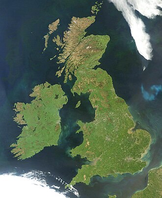 A 2012 NASA satellite image of the British Isles, excluding Shetland and the Channel Islands which are out of the frame | |
 | |
| Geography | |
| Location | North-western Europe |
| Coordinates | 54°N 4°W / 54°N 4°W |
| Adjacent to | Atlantic Ocean |
| Total islands | 6,000+ |
| Area | 315,159 km2 (121,684 sq mi) |
| Highest elevation | 1,345 m (4413 ft) |
| Highest point | Ben Nevis, Scotland |
| Demographics | |
| Population | 71,891,524 (2019) |
| Pop. density | 216/km2 (559/sq mi) |
| Languages | English, Welsh, Cornish, Irish, Manx, Scots, Scottish Gaelic, French, Guernésiais, Jèrriais, Sercquiais, Shelta, Ulster-Scots, Angloromani, British Sign Language, Irish Sign Language |
| Additional information | |
| Time zone |
|
| • Summer (DST) |
|
| Drives on the | left |
| |
The oldest rocks are 2.7 billion years old and are found in Ireland, Wales and the north-west of Scotland. During the Silurian period, the north-western regions collided with the south-east, which had been part of a separate continental landmass. The topography of the islands is modest in scale by global standards. Ben Nevis, the highest mountain, rises to only 1,345 metres (4,413 ft), and Lough Neagh, which is notably larger than other lakes in the island group, covers 390 square kilometres (151 sq mi). The climate is temperate marine, with cool winters and warm summers. The North Atlantic drift brings significant moisture and raises temperatures 11 °C (20 °F) above the global average for the latitude. This led to a landscape that was long dominated by temperate rainforest, although human activity has since cleared the vast majority of forest cover. The region was re-inhabited after the last glacial period of Quaternary glaciation, by 12,000 BC, when Great Britain was still part of a peninsula of the European continent. Ireland was connected to Great Britain by the British-Irish Ice Sheet before 14,000 BC, and was not inhabited until after 8000 BC. Great Britain became an island by 7000 BC with the flooding of Doggerland.
The Gaels (Ireland), Picts (northern Great Britain) and Britons (southern Great Britain), all speaking Insular Celtic languages, inhabited the islands at the beginning of the 1st millennium BC. Much of Brittonic-occupied Britain was conquered by the Roman Empire from AD 43. The first Anglo-Saxons arrived as Roman power waned in the 5th century, and eventually they dominated the bulk of what is now England. Viking invasions began in the 9th century, followed by more permanent settlements and political change, particularly in England. The Norman conquest of England in 1066 and the later Angevin partial conquest of Ireland from 1169 led to the imposition of a new Norman ruling elite across much of Britain and parts of Ireland. By the Late Middle Ages, Great Britain was separated into the Kingdom of England and Kingdom of Scotland, while control in Ireland fluxed between Gaelic kingdoms, Hiberno-Norman lords and the English-dominated Lordship of Ireland, soon restricted only to the Pale. The 1603 Union of the Crowns, Acts of Union 1707 and Acts of Union 1800 aimed to consolidate Great Britain and Ireland into a single political unit, the United Kingdom of Great Britain and Ireland, with the Isle of Man and the Channel Islands remaining as Crown Dependencies. The expansion of the British Empire and migrations following the Irish Famine and Highland Clearances resulted in the dispersal of some of the islands' population and culture throughout the world, and rapid depopulation of Ireland in the second half of the 19th century. Most of Ireland seceded from the United Kingdom after the Irish War of Independence and the subsequent Anglo-Irish Treaty (1919–1922), with six counties remaining in the UK as Northern Ireland.
As a term, "British Isles" is a geographical name and not a political unit; nevertheless, there are objections to its usage in relation to Ireland due to the political interpretation of the word "British". The Government of Ireland does not officially recognise the term and its embassy in London discourages its use. "Britain and Ireland" is used as an alternative description, and "Atlantic Archipelago" has also seen limited use in academia. In official documents created jointly by Ireland and the United Kingdom, such as the Good Friday Agreement, the term "these islands" is used.
Etymology
The earliest known references to the islands as a group appeared in the writings of seafarers from the ancient Greek colony of Massalia. The original records have been lost; however, later writings, e.g. Avienius's Ora maritima, that quoted from the Massaliote Periplus (6th century BC) and from Pytheas's On the Ocean (around 325–320 BC) have survived.
In the 1st century BC, Diodorus Siculus has Prettanikē nēsos, "the British Island", and Prettanoi, "the Britons", describes Julius Caesar as having "advanced the Roman Empire as far as the British Isles" (Greek: μέχρι τῶν Βρεττανικῶν νήσων, romanized: mékhri tôn Brettanikôn nḗsōn), and remarks on the region "about the British Isles" (τὸ περὶ τὰς Βρεττανικὰς νήσους, tò perì tàs Brettanikàs nḗsous). According to Philip Freeman in 2001, "it seems reasonable, especially at this early point in classical knowledge of the Irish, for Diodorus or his sources to think of all inhabitants of the Brettanic Isles as Brettanoi".
Strabo used Βρεττανική (Brettanike), and Marcian of Heraclea, in his Periplus maris exteri, used αἱ Πρεττανικαί νῆσοι (the Prettanic Isles) to refer to the islands.
According to A. L. F. Rivet and Colin Smith in 1979 "the earliest instance of the name which is textually known to us" is in The Histories of Polybius, who referred to them as: αἱ Βρεταννικαί νήσοι, romanized: hai Bretannikai nēsoi, lit. 'the Brettanic Islands' or 'the British Isles'. According to Rivet and Smith, this name encompassed "Britain with Ireland". According to Thomas O'Loughlin in 2018, the British Isles was "a concept already present in the minds of those living in continental Europe since at least the 2nd–cent. CE".
Historians today, though not in absolute agreement, largely agree that these Greek and Latin names were probably drawn from native Celtic-language names for the archipelago. Along these lines, the inhabitants of the islands were called the Πρεττανοί (Priteni or Pretani). The shift from the "P" of Pretannia to the "B" of Britannia by the Romans occurred during the time of Julius Caesar.
Greco-Egyptian Claudius Ptolemy referred to the larger island as great Britain (μεγάλη Βρεττανία megale Brettania) and to Ireland as little Britain (μικρὰ Βρεττανία mikra Brettania) in his work Almagest (147–148 AD). According to Philip Freeman in 2001, Ptolemy "is the only ancient writer to use the name "Little Britain" for Ireland, though in doing so he is well within the tradition of earlier authors who pair a smaller Ireland with a larger Britain as the two Brettanic Isles". In the second book of Ptolemy's Geography (c. 150 AD), the second and third chapters are respectively titled in Greek: Κεφ. βʹ Ἰουερνίας νήσου Βρεττανικῆς θέσις, romanized: Iouernías nḗsou Brettanikê̄s thésis, lit. 'Ch. 2, position of Hibernia, a British island' and Κεφ. γʹ Ἀλβουίωνος νήσου Βρεττανικῆς θέσις, Albouíōnos nḗsou Brettanikê̄s thésis, 'Ch. 3, position of Albion, a British island'.
In Arabic geography and cartography in the medieval Islamic world, the British Isles are known as Jazāʾir Barṭāniya or Jazāʾir Barṭīniya. Arabic geographies, including the Kitāb az-Zīj of al-Battānī, mention the British Isles as twelve islands.
John Skelton's English translation of Diodorus Siculus's Bibliotheca historica, written in the middle 1480s, mentions the British Isles as the yles of Bretayne. Thomas Twyne's English translation of Dionysius Periegetes's Orbis descriptio, published in 1572, mentions the British Isles as the Iles of Britannia. The earliest citation of the phrase Brytish Iles in the Oxford English Dictionary is in a work by John Dee dated 1577.
Other names used to describe the islands include the Anglo-Celtic Isles, Atlantic archipelago (a term coined by the historian J. G. A. Pocock in 1975), British-Irish Isles, Britain and Ireland, UK and Ireland, and British Isles and Ireland. Owing to political and national associations with the word British, the Government of Ireland does not use the term British Isles and in documents drawn up jointly between the British and Irish governments, the archipelago is referred to simply as "these islands". British Isles is the most widely accepted term for the archipelago.
Geography

The British Isles lie at the juncture of several regions with past episodes of tectonic mountain building. These orogenic belts form a complex geology that records a huge and varied span of Earth's history. Of particular note was the Caledonian orogeny during the Ordovician and early Silurian periods, when the craton Baltica collided with the terrane Avalonia to form the mountains and hills in northern Britain and Ireland. Baltica formed roughly the north-western half of Ireland and Scotland. Further collisions caused the Variscan orogeny in the Devonian and Carboniferous periods, forming the hills of Munster, south-west England, and southern Wales. Over the last 500 million years the land that forms the islands has drifted north-west from around 30°S, crossing the equator around 370 million years ago to reach its present northern latitude.
The islands have been shaped by numerous glaciations during the Quaternary Period, the most recent being the Devensian. As this ended, the central Irish Sea was deglaciated and the English Channel flooded, with sea levels rising to current levels some 8,000 years ago, leaving the British Isles in their current form.
There are about 136 permanently inhabited islands in the group, the largest two being Great Britain and Ireland. Great Britain is to the east and covers 83,700 sq mi (217,000 km2). Ireland is to the west and covers 32,590 sq mi (84,400 km2). The largest of the other islands are to be found in the Hebrides, Orkney and Shetland to the north, Anglesey and the Isle of Man between Great Britain and Ireland, and the Channel Islands near the coast of France. The most densely populated island is Portsea Island, which has an area of 9.5 mi2 (25 km2) but has the third highest population behind Great Britain and Ireland.
The islands are at relatively low altitudes, with central Ireland and southern Great Britain particularly low-lying: the lowest point in the islands is the North Slob in County Wexford, Ireland, with an elevation of −3.0 metres (−9.8 ft). The Scottish Highlands in the northern part of Great Britain are mountainous, with Ben Nevis being the highest point on the islands at 1,345 m (4,413 ft). Other mountainous areas include Wales and parts of Ireland, although only seven peaks in these areas reach above 1,000 m (3,281 ft). Lakes on the islands are generally not large, although Lough Neagh in Northern Ireland is an exception, covering 150 square miles (390 km2).[citation needed] The largest freshwater body in Great Britain by area is Loch Lomond at 27.5 square miles (71 km2) and Loch Ness is the largest by volume whilst Loch Morar is the deepest freshwater body in the British Isles, with a maximum depth of 310 m (1,017 ft). There are a number of major rivers within the British Isles. The longest is the Shannon in Ireland at 224 mi (360 km). The river Severn at 220 mi (354 km) is the longest in Great Britain.
Climate
The climate of the British Isles is mild, moist and changeable with abundant rainfall and a lack of temperature extremes. It is defined as a temperate oceanic climate, or Cfb on the Köppen climate classification system, a classification it shares with most of north-west Europe. The North Atlantic Drift (Gulf Stream), which flows from the Gulf of Mexico, brings with it significant moisture and raises temperatures 11 °C (20 °F) above the global average for the islands' latitudes. Most Atlantic depressions pass to the north of the islands; combined with the general westerly circulation and interactions with the landmass, this imposes a general east–west variation in climate. There are four distinct climate patterns: south-east, with cold winters, warm and dry summers; south-west, having mild and very wet winters, warm and wet summers; north-west, generally wet with mild winters and cool summers; and north-east with cold winters, cool summers.
Flora and fauna

The islands have a mild climate and varied soils, giving rise to a diverse pattern of vegetation. Animal and plant life is similar to that of the north-western European mainland. However there are fewer numbers of species, with Ireland having even fewer. All native flora and fauna in Ireland is made up of species that migrated primarily from Great Britain. The only window when this could have occurred was prior to the melting of the ice bridge between the two islands 14,000 years ago, approaching the end of the last ice age.
As with most of Europe, prehistoric Britain and Ireland were covered with forest and swamp. Clearing began around 6000 BC and accelerated in medieval times. Despite this, Britain retained its primeval forests longer than most of Europe owing to a small population and later development of trade and industry, and wood shortages were not a problem until the 17th century. By the 18th century most of Britain's forests were consumed for shipbuilding or manufacturing charcoal and the nation was forced to import lumber from Scandinavia, North America and the Baltic. Most forest land in Ireland is maintained by state forestation programmes. Almost all land outside urban areas is farmland. However relatively large areas of forest remain in east and north Scotland and in southeast England. Oak, elm, ash and beech are amongst the most common trees in England. In Scotland pine and birch are most common. Natural forests in Ireland are mainly oak, ash, wych elm, birch and pine. Beech and lime, though not native to Ireland, are also common there. Farmland hosts a variety of semi-natural vegetation of grasses and flowering plants. Woods, hedgerows, mountain slopes and marshes host heather, wild grasses, gorse and bracken.
Many larger animals, such as wolves, bears and European elk, are today extinct. However some species, such as red deer, are protected. Other small mammals, such as rabbits, foxes, badgers, hares, hedgehogs and stoats, are very common and the European beaver has been reintroduced in parts of Scotland. Wild boar have also returned to parts of southern England following escapes from farms and illegal releases. Many rivers contain otters and grey and common seals are numerous on coasts. There are about 250 bird species regularly recorded in Great Britain and another 350 that occur with varying degrees of rarity. The most numerous species are wren, robin, house sparrow, woodpigeon, chaffinch and blackbird. Farmland birds are declining in number, except for those bred for “sport”, such as pheasant, red-legged partridge and red grouse. Fish are abundant in the rivers and lakes, in particular salmon, trout, perch and pike. Sea fish include dogfish, cod, sole, pollock and bass, as well as mussels, crab and oysters along the coast. There are more than 21,000 species of insect.
Few species of reptiles or amphibians are found in Great Britain or Ireland. Only three snakes are native to Great Britain: the adder, the barred grass snake and the smooth snake; none are native to Ireland. In general Great Britain has slightly more variation and native wildlife, with weasels, polecats, wildcats, most shrews, moles, water voles, roe deer and common toads also being absent from Ireland. This pattern is also true for birds and insects. Notable exceptions include the Kerry slug and certain species of woodlouse native to Ireland but not Great Britain.
Domestic and domesticated animals include the Connemara pony, Shetland pony, English Mastiff, Irish Wolfhound and many breeds of cattle and sheep.
Demographics

England has a generally high population density, with almost 80% of the total population of the islands. Elsewhere in Great Britain and Ireland, high density of population is limited to areas around a few large cities. The largest urban area by far is the Greater London Built-up Area with 9 million inhabitants. Other major population centres include the Greater Manchester Built-up Area (2.4 million), West Midlands conurbation (2.4 million) and West Yorkshire Urban Area (1.6 million) in England, Greater Glasgow (1.2 million) in Scotland and Greater Dublin Area (1.9 million) in Ireland.
The population of England rose rapidly during the 19th and 20th centuries, whereas the populations of Scotland and Wales showed little increase during the 20th century; the population of Scotland has remained unchanged since 1951. Ireland for most of its history had much the same population density as Great Britain (about one-third of the total population). However since the Great Irish Famine the population of Ireland has fallen to less than one-tenth of the population of the British Isles. The famine caused a century-long population decline, drastically reduced the Irish population and permanently altered the demographic make-up of the British Isles. On a global scale, this disaster led to the creation of an Irish diaspora that numbers fifteen times the current population of the island.
The linguistic heritage of the British Isles is rich, with twelve languages from six groups across four branches of the Indo-European family. The Insular Celtic languages of the Goidelic sub-group (Irish, Manx and Scottish Gaelic) and the Brittonic sub-group (Cornish, Welsh and Breton, spoken in north-western France) are the only remaining Celtic languages—the last of their continental relations were extinct before the 7th century. The Norman languages of Guernésiais, Jèrriais and Sercquiais spoken in the Channel Islands are similar to French, a language also spoken there. A cant, called Shelta, is spoken by Irish Travellers, often to conceal meaning from those outside the group. However, English, including Scots, is the dominant language, with few monoglots remaining in the other languages of the region. The Norn language of Orkney and Shetland became extinct around 1880.
Urban areas
| Rank | Urban area | Population | Country |
|---|---|---|---|
| 1 | London | 9,787,426 | England |
| 2 | Greater Manchester | 2,553,379 | England |
| 3 | West Midlands Conurbation | 2,440,986 | England |
| 4 | West Yorkshire Urban Area | 1,777,934 | England |
| 5 | Glasgow | 1,209,143 | Scotland |
| 6 | Dublin | 1,173,179 | Republic of Ireland |
| 7 | Liverpool | 864,122 | England |
| 8 | South Hampshire | 855,569 | England |
| 9 | Tyneside | 774,891 | England |
| 10 | Nottingham | 729,977 | England |
| 11 | Sheffield | 685,386 | England |
| 12 | Bristol | 617,280 | England |
| 13 | Belfast | 595,879 | Northern Ireland |
| 14 | Leicester | 508,916 | England |
| 15 | Edinburgh | 482,005 | Scotland |
| 16 | Brighton and Hove | 474,485 | England |
| 17 | Bournemouth | 466,266 | England |
| 18 | Cardiff | 481,082 | Wales |
| 19 | Teesside | 376,633 | England |
| 20 | Stoke-on-Trent | 372,775 | England |
| 21 | Coventry | 359,262 | England |
| 22 | Sunderland | 335,415 | England |
| 23 | Birkenhead | 325,264 | England |
| 24 | Reading | 318,014 | England |
| 25 | Kingston-upon-Hull | 314,018 | England |
| 26 | Preston | 313,322 | England |
| 27 | Newport | 306,844 | Wales |
| 28 | Swansea | 300,352 | Wales |
| 29 | Southend-on-Sea | 295,310 | England |
| 30 | Derby | 270,468 | England |
| 31 | Plymouth | 260,203 | England |
| 32 | Luton | 258,018 | England |
| 33 | Aldershot | 252,397 | England |
| 34 | Medway | 243,931 | England |
| 35 | Blackpool | 239,409 | England |
| 36 | Milton Keynes | 229,431 | England |
| 37 | Barnsley | 223,281 | England |
| 38 | Cork | 222,000 | Republic of Ireland |
| 39 | Northampton | 215,963 | England |
| 40 | Norwich | 213,166 | England |
| 41 | Aberdeen | 207,932 | Scotland |
History
wikipedia, wiki, encyclopedia, book, article, read, free download, Information about british isles. What is british isles? What does british isles mean?