 Azərbaycanca (AZ)
 Deutsch (DE)
 English (US)
 Қазақша (KZ)
 Lietuva (LT)
 සිංහල (LK)
 Türkçe (TR)
 O'zbekcha (UZ)
 中國人 (CN)
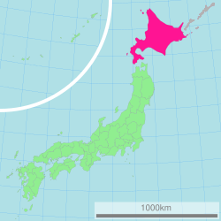
Hokkaido is the second-largest and northernmost of Japan's four main islands. Together with its surrounding islands, it comprises the largest and northernmost prefecture, making up its own region. The Tsugaru Strait separates Hokkaido from Honshu. The two islands are connected by railway via the Seikan Tunnel.
Hokkaido | |
|---|---|
Prefecture and region | |
| Japanese transcription(s) | |
| • Kanji | 北海道 |
| • Rōmaji | Hokkaidō |
| Ainu transcription(s) | |
| • Katakana | アィヌ モシㇼ |
| • Latin script | Aynu Mosir |
 Flag  Symbol | |
| Anthem: Hikari afurete, Mukashi no mukashi and Hokkai bayashi | |
 | |
| Coordinates: 43°N 142°E / 43°N 142°E | |
| Country | Japan |
| Island | Hokkaido |
| Region | Hokkaido |
| Capital | Sapporo |
| Largest city | Sapporo |
| Subdivisions | Districts: 74, Municipalities: 179 |
| Government | |
| • Body | Hokkaido Legislative Assembly |
| • Governor | Naomichi Suzuki |
| Area | |
• Total | 83,423.84 km2 (32,210.12 sq mi) |
| • Rank | 1st |
| Population (January 31, 2026) | |
• Total | 4,991,369 |
| • Rank | 8th |
| • Density | 59.83145/km2 (154.9627/sq mi) |
| GDP (2022) | |
| • Total | JPY 20,889 billion USD 154.3 billion |
| ISO 3166 code | JP-01 |
| Website | www |
| Symbols of Hokkaido | |
| Bird | Tanchō (red-crowned crane, Grus japonensis) |
| Flower | Hamanasu (rugosa rose, Rosa rugosa) |
| Mascot | Kyun-chan (キュンちゃん) |
| Tree | Ezomatsu (Jezo spruce, Picea jezoensis) |
The largest city on Hokkaido is its capital, Sapporo, which is also its only ordinance-designated city. Sakhalin lies about 43 kilometres (27 mi) to the north of Hokkaido. To the east and northeast are the Kuril Islands, which are administered by Russia. The four most southerly are claimed by Japan. Hokkaido's position on the northern end of the Japanese archipelago results in a colder climate, with the island seeing significant snowfall each winter. Despite the harsher climate, it serves as an agricultural breadbasket for many crops.
Hokkaido was formerly known as Ezo, Ezochi, and Ezogashima. Although Japanese settlers ruled the southern tip of the island since the 16th century, Hokkaido was primarily inhabited by the Ainu people. In 1869, following the Meiji Restoration, the entire island was annexed, colonized, and renamed Hokkaido by Japan. Japanese settlers dispossessed the Ainu of their land and forced them to assimilate. In the 21st century, the Ainu are almost totally assimilated into Japanese society. As a result, the majority of Japanese people of Ainu descent have no knowledge of their heritage or culture.
Names

When establishing the Development Commission, the Meiji government decided to change the name of Ezochi. Matsuura Takeshirō submitted six proposals, including names such as Kaihokudō (海北道) and Hokkaidō (北加伊道), to the government. The government eventually decided to use the name Hokkaido, but decided to write it as 北海道, as a compromise between 海北道 and 北加伊道 because of the similarity with names such as Tōkaidō (東海道). According to Matsuura, the name was thought up because the Ainu called the region Kai. The kai element also strongly resembles the On'yomi, or Sino-Japanese, reading of the characters 蝦夷 (on'yomi as [ka.i, カイ], kun'yomi as [e.mi.ɕi, えみし]), which have been used for over a thousand years in China and Japan as the standard orthographic form to be used when referring to Ainu and related peoples. It is possible that Matsuura's kai was actually an alteration, influenced by the Sino-Japanese reading of 蝦夷 Ka-i, of the Nivkh exonym for the Ainu, namely Qoy (Gilyak pronunciation: [kʰuɣɪ]).
In 1947, Hokkaido became a full-fledged prefecture. The historical suffix 道 (-dō) translates to "prefecture" in English, ambiguously the same as 府 (-fu) for Osaka and Kyoto, and 県 (-ken) for the rest of the prefectures. Dō, as shorthand, can be used to uniquely identify Hokkaido, for example as in 道道 (dōdō, "Hokkaido road") or 道議会 (Dōgikai, "Hokkaido Assembly"), the same way 都 (-to) is used for Tokyo. The prefecture's government calls itself the "Hokkaido Government" rather than the "Hokkaido Prefectural Government".[citation needed]
With the rise of indigenous rights movements, there emerged a notion that Hokkaido should have an Ainu-language name. If a decision to change the name is made, however, whichever Ainu phrase is chosen, its original referent is critically different from the large geographical entity. The phrase aynumosir (アイヌモシㇼ) has been a preferred choice among Japanese activists. Its primary meaning is the "land of humans", as opposed to the "land of gods" (kamuymosir). When contrasted with sisammosir ("land of the neighbors", often pointing to Honshu or Japanese settlements on the southern tip of Hokkaido), it means the land of the Ainu people, which, depending on context, can refer to Hokkaido, although from a modern ethnolinguistic point of view, the Ainu people have extended their domain to a large part of Sakhalin and the entire Kuril Islands.[citation needed] Another phrase, yaunmosir (ヤウンモシㇼ), has gained prominence; it literally means the "onshore land", as opposed to the "offshore land" (repunmosir), which, depending on context, can refer to the Kuril Islands, Honshu, or any foreign country. If the speaker is a resident of Hokkaido, yaunmosir can refer to Hokkaido. Yet another phrase, akormosir (アコㇿモシㇼ) means "our (inclusive) land", and when used by Hokkaido Ainus, it can refer to Hokkaido or Japan as a whole.
History
Early history
During the Jomon period, the local culture and the associated hunter-gatherer lifestyle flourished in Hokkaido, beginning over 15,000 years ago. In contrast to the island of Honshu, Hokkaido saw an absence of conflict during this time period. Jomon beliefs in natural spirits are theorized to be the origins of Ainu spirituality. About 2,000 years ago, the island was colonized by Yayoi people, and much of the island's population shifted away from hunting and gathering towards agriculture.
The Ebetsu Kofun Cluster is a group of mounds dating from the latter half of the 8th century to the middle of the 9th century, and were surveyed by Juichi Goto in 1931. Along with the kofun, warabidetoh (蕨手刀), iron sword, magatama, and sueki were discovered. Ebetsu Kofun is known to be evidence for the existence of Wajin (和人) and trade between Hokkaido and Honshu before Feudal Japan.
The Nihon Shoki, finished in 720 AD, is often said to be the first mention of Hokkaido in recorded history. According to the text, Abe no Hirafu led a large navy and army to the northern areas from 658 to 660 and came into contact with the Mishihase and Emishi. One of the places Hirafu went to was called Watarishima (渡島), which is often believed to be present-day Hokkaido. However, many theories exist concerning the details of this event, including the location of Watarishima and the common belief that the Emishi in Watarishima were the ancestors of the present-day Ainu people.[citation needed]
During the Nara and Heian periods (710–1185), people in Hokkaido conducted trade with Dewa Province, an outpost of the Japanese central government. From the feudal period, the people in Hokkaido began to be called Ezo. Hokkaido subsequently became known as Ezochi (蝦夷地; lit. 'Ezo land' or 'Ezo region') or Ezogashima (蝦夷ヶ島; lit. 'Island of the Ezo'). The indigenous people of Ezochi mainly relied upon hunting and fishing and obtained rice and iron through trade with the Japanese.[citation needed]
Feudal Japan

During the Muromachi period (1336–1573), the Japanese established a settlement at the south of the Oshima Peninsula, with a series of fortified residences such as that of Shinoridate. As more people moved to the settlement to avoid battles, disputes arose between the Japanese and the Ainu. The disputes eventually developed into a war. In 1457, Takeda Nobuhiro (1431–1494) killed the Ainu leader, Koshamain, and defeated the opposition. Nobuhiro's descendants became the rulers of the Matsumae-han, which was granted exclusive trading rights with the Ainu in the Azuchi-Momoyama and Edo periods (1568–1868). The Matsumae family's economy relied upon trade with the Ainu, who had extensive trading networks. The Matsumae held authority over the south of Ezochi until the end of the Edo period.


The Matsumae clan's rule over the Ainu must be understood in the context of the expansion of the Japanese feudal state. Medieval military leaders in northern Honshu (e.g. Northern Fujiwara, Akita clan) maintained only tenuous political and cultural ties to the imperial court and its proxies, the Kamakura shogunate and Ashikaga shogunate. Feudal strongmen sometimes defined their own roles within the medieval institutional order, taking shogunate titles, while in other times they assumed titles that seemed to give them a non-Japanese identity. Many of the feudal strongmen were descended from Emishi military leaders who had been assimilated into Japanese society.
The Matsumae clan were of Yamato descent like other ethnic Japanese people, whereas the Emishi of northern Honshu were a distinctive group related to the Ainu. The Emishi were conquered and integrated into the Japanese state dating as far back as the 8th century and as a result began to lose their distinctive culture and ethnicity as they became minorities. By the time the Matsumae clan ruled over the Ainu, most of the Emishi were ethnically mixed and physically closer to Japanese than they were to Ainu. From this, the "transformation" theory postulates that native Jomon peoples changed gradually with the infusion of Yayoi immigrants into the Tōhoku region of northern Honshu, in contrast to the "replacement" theory that posits the Jomon were replaced by the Yayoi.

There were numerous revolts by the Ainu against feudal rule. The last large-scale resistance was Shakushain's revolt in 1669–1672. In 1789, a smaller movement known as the Menashi–Kunashir rebellion was crushed, after which the terms "Japanese" and "Ainu" referred to clearly distinguished groups, and the Matsumae were unequivocally Japanese.[citation needed]
According to American professor of Japanese history John A. Harrison, prior to 1868 Japan used proximity as its claim to Hokkaido, Sakhalin, and the Kuril Islands. However, Japan had never thoroughly explored, governed, or exploited the areas, and this claim was invalidated by the movement of Russia into the Northeast Pacific area and by Russian settlements on Kamchatka (from 1699), Sakhalin (1850s) and the Sea of Okhotsk Coast (1640s onwards).
Prior to the Meiji Restoration of 1868, Hokkaido was seen as a frontier land and the Tokugawa shogunate realized the need to prepare northern defenses against a possible Russian invasion and took over control of most of Ezochi in 1855–1858. Many Japanese settlers regarded the Ainu as "inhuman and the inferior descendants of dogs". The Tokugawa irregularly imposed various assimilation programs on the Ainu due to the Tokugawa's perception of them as a threat from Russia. For example, assimilation programs were implemented in response to perceived threats from Russia, which included the Laxman expedition of 1793 and the Golovnin Incident of 1804. Once the respective Russian threats appeared to subside, the assimilation programs were halted until 1855. However, in 1855, once the Treaty of Shimoda was signed, which defined the borders between Russian Empire and Tokugawa Japan, the Tokugawa again viewed Russia as a threat to Japanese sovereignty over Hokkaido and reinstated assimilation programs on the Ainu.
Meiji era
Colonization of Hokkaido
Prior to the Meiji era, the island was called Ezochi, which can be translated as "land of the barbarians" or "the land for people who did not obey the government." Shortly after the Boshin War in 1868, a group of Tokugawa loyalists led by Enomoto Takeaki temporarily occupied the island (the polity is commonly but mistakenly known as the Republic of Ezo), but the rebellion was defeated in May 1869. Through colonial practices, Ezochi was annexed into Japanese territory. Ezochi was subsequently put under control of Hakodate Prefectural Government. When establishing the Development Commission (開拓使, Kaitakushi), the Meiji government introduced a new name, Hokkaido, which can be translated to "northern sea route". Regional subdivisions were established, including the provinces of Oshima, Shiribeshi, Iburi, Ishikari, Teshio, Kitami, Hidaka, Tokachi, Kushiro, Nemuro and Chishima.
Japanese proponents of Ezochi's colonization argued that it would serve as a strategic move to enhance Japan's standing and influence on the global stage, particularly in negotiations with Western powers, specifically Russia. The Meiji government invested heavily in colonizing Hokkaido for several reasons. Firstly, they aimed to assert their control over the region as a buffer against potential Russian advances. Secondly, they were attracted to Hokkaido's rich natural resources, including coal, timber, fish, and fertile land. Lastly, since Western powers viewed colonial expansion as a symbol of prestige, Japan viewed the colonization of Hokkaido as an opportunity to present itself as a modern and respected nation to Western powers.


The primary purpose of the Development Commission was to secure Hokkaido before the Russians extended their control of the Far East beyond Vladivostok. The Japanese failed to settle in the interior lowlands of the island because of aboriginal resistance. The resistance was eventually destroyed, and the lowlands were under the control of the commission. The most important goal of the Japanese was to increase the farm population and to create a conducive environment for emigration and settlement. However, the Japanese did not have expertise in modern agricultural techniques, and only possessed primitive mining and lumbering methods. Kuroda Kiyotaka was put in charge of the project, and turned to the United States for help.
His first step was to journey to the United States and recruit Horace Capron, US President Ulysses S. Grant's commissioner of agriculture. From 1871 to 1873, Capron bent his efforts to expounding Western agriculture and mining, with mixed results. Frustrated with obstacles to his efforts, Capron returned home in 1875. In 1876, William S. Clark arrived to establish an agricultural college in Sapporo. Although he only remained for a year, Clark left a lasting impression on Hokkaido, inspiring the Japanese with his teachings on agriculture as well as Christianity. His parting words, "Boys, be ambitious!", can be found on public buildings in Hokkaido to this day. The population of Hokkaido increased from 58,000 to 240,000 during that decade.
Kuroda hired Capron for US$10,000 per year and paid for all expenses related to the mission. Kuroda and his government were likely intrigued by Capron's previous colonial experience, particularly his involvement in the forced removal of Native Americans from Texas to new territories after the Mexican–American War. Capron introduced capital-intensive farming techniques by adopting American methods and tools, importing seeds for Western crops, and bringing in European livestock breeds, which included his favorite North Devon cattle. He founded experimental farms in Hokkaido, conducted surveys to assess mineral deposits and agricultural potential, and advocated for improvements in water access, mills, and roads.
The settler colonization of Hokkaido by the Japanese was organized and supported through collaboration between the Japanese state and American experts and technology. From the 1870s to the 1880s, Japanese leaders placed their efforts on settling Hokkaido by systematically migrating former samurai lords, samurai retainers, and common citizens, which included farmers and peasants, providing them with "free" land and financial assistance. This transformation was facilitated with the expertise of American advisors who introduced various colonization technologies, transforming Hokkaido into land suitable for Japan's capitalist aspirations.
Japanese leaders drew inspiration from American settler colonialism during their diplomatic visits to the United States. Japanese colonial officials learned settler colonial techniques from Western imperial powers, particularly the United States. This included declaring large portions of Hokkaido as ownerless land, providing a pretext for the dispossession of the Ainu people. Japan established the Hokkaido Colonization Board in 1869, a year after the start of the Meiji era, with the goal of encouraging Japanese settlers to Hokkaido. Mainland Japanese settlers began migrating to Hokkaido, leading to Japan's colonization of the island. Motivated by capitalist and industrial goals, the Meiji government forcefully appropriated fertile land and mineral-rich regions throughout Hokkaido, without consideration for their historical Ainu inhabitancy. The Meiji government implemented land seizures and enacted land ownership laws that favored Japanese settlers, effectively stripping Ainu people of their customary land rights and traditional means of subsistence. The 1899 Hokkaido Former Aborigines Protection Act further marginalized and impoverished the Ainu people by forcing them to leave their traditional lands and relocating them to the rugged, mountainous regions in the center of the island. The act prohibited the Ainu from fishing and hunting, which were their main source of subsistence. The Ainu were valued primarily as a source of inexpensive manual labor, and discriminatory assimilation policies further entrenched their sense of inferiority as well as worsened poverty and disease within Ainu communities. These policies exacerbated diasporic trends among the Ainu population, as many sought employment with the government or private enterprises, often earning meager wages that barely sustained their families.
The Meiji government embarked on assimilation campaigns aimed not only at assimilating the Ainu but also eradicating their language and culture entirely. They were forced to take on Japanese names and language, and gradually saw their culture and traditions eroded. The Ainu were forbidden to speak their own language and taught only Japanese at school. Facing pervasive stigma, many Ainu concealed their heritage. UNESCO has recognized the Ainu language as critically endangered. Given the Meiji state's full political control over the island, the subsequent subjugation of its indigenous inhabitants, aggressive economic exploitation, and ambitious permanent settlement endeavors, Hokkaido emerged as the sole successful settler colony of Japan.
After the Meiji colonization of Hokkaido, Meiji Japan depended on prison labour to accelerate the colonization process. The Japanese built three prisons and rendered Hokkaido a prison island, where political prisoners were incarcerated and used as prison labour. During the opening ceremony of the first prison, the Ainu name "Shibetsuputo" was replaced with the Japanese name "Tsukigata", as an attempt to "Japanize" Hokkaido's geography. The second prison opened near the Hokutan Horonai coal mine, where Ainu people were forced to work. Cheap prison labour played an important role in coal and sulphur mining, as well as road construction in Hokkaido. Eventually, several types of indentured labour, Korean labour, child labour and women labour replaced convict labour in Hokkaido. Working conditions were difficult and dangerous. Japan's transition to capitalism depended heavily on the growth of the coal mining sector in Hokkaido. The importance of coal from Hokkaido increased throughout World War I, and the mines required a large amount of labourers.
World War II
In mid-July 1945, various shipping ports, cities, and military facilities in Hokkaido were attacked by the United States Navy's Task Force 38. On 14–15 July, aircraft operating from the task force's aircraft carriers sank and damaged a large number of ships in ports along Hokkaido's southern coastline as well as in northern Honshu. In addition, on 15 July a force of three battleships and two light cruisers bombarded the city of Muroran. Before the Japanese surrender was formalized, the Soviet Union made preparations for an invasion of Hokkaido, but US President Harry Truman made it clear that the surrender of all of the Japanese home islands would be accepted by US General Douglas MacArthur per the 1943 Cairo Declaration.
Present
Hokkaido became equal with other prefectures in 1947, when the revised Local Autonomy Act became effective. The Japanese central government established the Hokkaido Development Agency (北海道開発庁, Hokkaidō Kaihatsuchō) as an agency of the Prime Minister's Office in 1949 to maintain its executive power in Hokkaido. The agency was absorbed by the Ministry of Land, Infrastructure and Transport in 2001. The Hokkaido Bureau (北海道局, Hokkaidō-kyoku) and the Hokkaidō Regional Development Bureau (北海道開発局, Hokkaidō Kaihatsukyoku) of the ministry still have a strong influence on public construction projects in Hokkaido.
Geography
Native name: 北海道 | |
|---|---|
 | |
 Interactive map of Hokkaidō | |
| Geography | |
| Location | East Asia |
| Coordinates | 43°N 142°E / 43°N 142°E |
| Archipelago | Japanese archipelago |
| Area | 77,981.87 km2 (30,108.97 sq mi) |
| Highest elevation | 2,290 m (7510 ft) |
| Highest point | Mount Asahi |
| Administration | |
Japan | |
| Prefectures | Hokkaidō |
| Largest settlement | Sapporo (pop. 1,890,561) |
| Demographics | |
| Population | 5,377,435 (September 30, 2016) |
| Pop. density | 64.5/km2 (167.1/sq mi) |
| Ethnic groups | Ainu Japanese |
The island of Hokkaido is located in the north of Japan, near Russia (Sakhalin Oblast). It has coastlines on the Sea of Japan (to the west of the island), the Sea of Okhotsk (to the north), and the Pacific Ocean (to the east). The center of the island is mountainous, with volcanic plateaux. Hokkaido has multiple plains such as the Ishikari Plain 3,800 km2 (1,500 mi2), Tokachi Plain 3,600 km2 (1,400 mi2), the Kushiro Plain 2,510 km2 (970 mi2) (the largest wetland in Japan) and Sarobetsu Plain 200 km2 (77 mi2). Hokkaido is 83,423.84 km2 (32,210.12 mi2) which make it the second-largest island of Japan.
The Tsugaru Strait separates Hokkaido from Honshu (Aomori Prefecture); La Pérouse Strait separates Hokkaido from the island of Sakhalin in Russia; Nemuro Strait separates Hokkaido from Kunashir Island in the Russian Kuril Islands.
The governmental jurisdiction of Hokkaido incorporates several smaller islands, including Rishiri, Okushiri Island, and Rebun. By Japanese reckoning, Hokkaido also incorporates the four southernmost Kuril Islands. Hokkaido is the largest and northernmost Japanese prefecture. The island ranks 21st in the world by area.
-
 A satellite image of Hokkaido by Terra, May 2001
 - Hokkaido seen from the International Space Station
- Lake Tōya, a volcanic caldera lake
- Shiretoko Goko Lakes in the town of Shari, Okhotsk Subprefecture, Hokkaido
- The Oyashio Current colliding with the Kuroshio Current off the coast of Hokkaido
Flora and fauna
There are three populations of the Ussuri brown bear found on the island. There are more brown bears in Hokkaido than anywhere else in Asia besides Russia. The Hokkaido brown bear is separated into three distinct lineages. There are only eight lineages in the world. Those on Honshu died out long ago.
Hokkaido is also the historical and current range of Japan's sea otter population, which is increasingly becoming a major tourism draw as sea otters disappear from Japanese aquaria.
The native conifer species in northern Hokkaido is the Sakhalin fir (Abies sachalinensis). The flowering plant Hydrangea hirta is also found on the island.
Notable flora and fauna Name Type Notes Ussuri brown bear Fauna One of the largest populations by average size of brown bears (Ursus arctos lasiotus) Sea otter Fauna Heaviest species of mustelid (Enhydra lutris) Steller's sea eagle Fauna On average, the heaviest eagle species in the world (Haliaeetus pelagicus) Hokkaido wolf Fauna Extinct subspecies of the gray wolf (Canis lupus hattai). Yezo sika deer Fauna Large subspecies of the sika deer (Cervus nippon yesoensis) Ezoris Fauna Also called the Ezo squirrel (Sciurus vulgaris orientis) Ezo red fox Fauna Native to northern Japanese archipelago (Vulpes vulpes schrencki) Ezo tanuki Fauna Subspecies of raccoon dog native to Hokkaido (Nyctereutes viverrinus albus) Hokkaido dog Fauna A Spitz-type domesticated hunting dog perhaps descend from introduced Akitas Dosanko Fauna Also called the "Hokkaido horse" Sable Fauna (Martes zibellina) A species of marten which inhabits Hokkaido and Northern Asia. Viviparous lizard Fauna (Zootoca vivipara) Ezo salamander Fauna (Hynobius retardatus) Dolly Varden trout Fauna (Salvelinus malma) Japanese emperor Fauna National butterfly of Japan (ō-murasaki, "great purple") Grey Heron Fauna (Ardea cinerea) Long legged wading bird. Chum salmon Fauna (white salmon (白鮭 シロサケ) is native to middle and northern Honshu, Hokkaido and the North Pacific. Sockeye salmon Fauna (Oncorhynchus nerka, ベニザケ - Benizake) live in Hokkaido and the North Pacific. Ezo spruce Flora Picea jezoensis Sakhalin spruce Flora Picea glehnii Japanese rose Flora Rosa rugosa
Geologic activity
Like many areas of Japan, Hokkaido is seismically active. Aside from numerous earthquakes, the following volcanoes are considered still active (at least one eruption since 1850):
- Hokkaido Koma-ga-take
- Mount Meakan
- Mount Tarumae
- Mount Tokachi
- Mount Usu and Shōwa-shinzan
In 1993, an earthquake of magnitude 7.7 generated a tsunami which devastated Okushiri, killing 202 inhabitants. An earthquake of magnitude 8.3 struck near the island on September 26, 2003. On September 6, 2018, an earthquake of magnitude 6.6 struck with its epicenter near the city of Tomakomai, causing a blackout across the whole island. On May 16, 2021, an earthquake measuring 6.1 on the Richter scale struck off the coast of Hokkaido.
Parks
| Shiretoko National Park* | 知床 |
| Akan Mashu National Park | 阿寒 |
| Kushiro-shitsugen National Park | 釧路湿原 |
| Daisetsuzan National Park | 大雪山 |
| Shikotsu-Tōya National Park | 支笏洞爺 |
| Rishiri-Rebun-Sarobetsu National Park | 利尻礼文サロベツ |
| Hidakasanmyaku-Erimo-Tokachi National Park | 日高山脈襟裳十勝 |
* designated a World Heritage Site by UNESCO on 2005-07-14.
| Abashiri Quasi-National Park | 網走 |
| Niseko-Shakotan-Otaru Kaigan Quasi-National Park | ニセコ積丹小樽海岸 |
| Ōnuma Quasi-National Park | 大沼 |
| Shokanbetsu-Teuri-Yagishiri Quasi-National Park | 暑寒別天売焼尻 |
- Overview of Kushiro Wetland
- Lake Akan and Mount Meakan
- View of Lake Mashū
- Lake Shikotsu
- Sōunkyō, a gorge in the Daisetsu-zan Volcanic Area
- Twelve prefectural natural parks (道立自然公園). The prefectural natural parks cover 146,802 ha, the largest area of any prefecture.
- Akkeshi Prefectural Natural Park
- Esan Prefectural Natural Park
- Furano-Ashibetsu Prefectural Natural Park
- Hiyama Prefectural Natural Park
- Kariba-Motta Prefectural Natural Park
- Matsumae-Yagoshi Prefectural Natural Park
- North Okhotsk Prefectural Natural Park
- Nopporo Shinrin Kōen Prefectural Natural Park
- Notsuke-Fūren Prefectural Natural Park
- Sharidake Prefectural Natural Park
- Shumarinai Prefectural Natural Park
- Teshiodake Prefectural Natural Park
| since | ||
|---|---|---|
| Kushiro Wetland | 釧路湿原 | 1980-06-17 |
| Lake Kutcharo | クッチャロ湖 | 1989-07-06 |
| Lake Utonai | ウトナイ湖 | 1991-12-12 |
| Kiritappu Wetland | 霧多布湿原 | 1993-06-10 |
| Lake Akkeshi, Bekkanbeushi Wetland | 厚岸湖・別寒辺牛湿原 | 1993-06-10, enlarged 2005-11-08 |
| Miyajima Marsh | 宮島沼 | 2002-11-18 |
| Uryūnuma Wetland | 雨竜沼湿原 | 2005-11-08 |
| Sarobetsu plain | サロベツ原野 | |
| Lake Tōfutsu | 濤沸湖 | |
| Lake Akan | 阿寒湖 | |
| Notsuke Peninsula, Notsuke Bay | 野付半島・野付湾 | |
| Lake Fūren, Shunkunitai | 風蓮湖・春国岱 |
Climate
As Japan's coldest region, Hokkaido has relatively cool summers and icy/snowy winters. Most of the island falls in the humid continental climate zone with Köppen climate classification Dfb (hemiboreal) in most areas but Dfa (hot summer humid continental) in some inland lowlands. The average August temperature ranges from 17 to 22 °C (62.6 to 71.6 °F), while the average January temperature ranges from −12 to −4 °C (10.4 to 24.8 °F), in both cases depending on elevation and distance from the ocean, though temperatures on the western side of the island tend to be a little warmer than on the eastern. The highest temperature ever recorded is 39.5 °C (103.1 °F) on 26 May 2019.
The northern portion of Hokkaido falls into the taiga biome with significant snowfall. Snowfall varies widely from as much as 11 metres (400 in) on the mountains adjacent to the Sea of Japan down to around 1.8 metres (71 in) on the Pacific coast. The island tends to have isolated snowstorms that develop long-lasting snowbanks. Total precipitation varies from 1,600 millimetres (63 in) on the mountains of the Sea of Japan coast to around 800 millimetres (31 in) (the lowest in Japan) on the Sea of Okhotsk coast and interior lowlands and up to around 1,100 millimetres (43 in) on the Pacific side. The generally high quality of powder snow and numerous mountains in Hokkaido make it a popular region for snow sports. The snowfall usually commences in earnest in November and ski resorts (such as those at Niseko, Furano, Teine and Rusutsu) usually operate between December and April. Hokkaido celebrates its winter weather at the Sapporo Snow Festival.[citation needed]
Hokkaido’s winter snowfall is driven by a seasonal atmospheric pattern between Siberia and the North Pacific. During winter, the Eurasian continent receives limited solar energy and cools rapidly, forming a strong and persistent high-pressure system over Siberia known as the Siberian High. At the same time, the North Pacific retains heat longer and forms a persistent low-pressure system called the Aleutian Low. The resulting pressure difference generates steady northwesterly winds that carry very cold, dry air toward Japan. As this air crosses the Sea of Japan, it passes over the Tsushima Warm Current, which keeps coastal waters relatively warm and enables significant moisture uptake. When the moisture-laden air reaches Hokkaido’s mountainous coastline, it is forced upward, condenses, and produces significant snowfall. This is an effect often referred to as ocean-effect snowfall. Despite the common assumption that La Niña brings heavier snow, long-term observations show no consistent correlation between La Niña phases and increased snowfall in Hokkaido.
During the winter, passage through the Sea of Okhotsk is often complicated by large floes of drift ice. Combined with high winds that occur during winter, this frequently brings air travel and maritime activity to a halt beyond the northern coast of Hokkaido. Ports on the open Pacific Ocean and Sea of Japan are generally ice-free year round, though most rivers freeze during the winter.[citation needed]
Unlike the other major islands of Japan, Hokkaido is normally not affected by the June–July rainy season and the relative lack of humidity and typically warm, rather than hot, summer weather makes its climate an attraction for tourists from other parts of Japan.[citation needed]
Temperature comparison
| City | Jan | Feb | Mar | Apr | May | Jun | Jul | Aug | Sep | Oct | Nov | Dec |
|---|---|---|---|---|---|---|---|---|---|---|---|---|
| Sapporo | −0.4 / −6.4 (31.3 / 20.5) | 0.4 / −6.2 (32.7 / 20.8) | 4.5 / −2.4 (40.1 / 27.7) | 11.7 / 3.4 (53.1 / 38.1) | 17.9 / 9.0 (64.2 / 48.2) | 21.8 / 13.4 (71.2 / 56.1) | 25.4 / 17.9 (77.7 / 64.2) | 26.4 / 19.1 (79.5 / 66.4) | 22.8 / 14.8 (73.0 / 58.6) | 16.4 / 8.0 (61.5 / 46.4) | 8.7 / 1.6 (47.7 / 34.9) | 2.0 / −4.0 (35.6 / 24.8) |
| Hakodate | 0.9 / −6.0 (33.6 / 21.2) | 1.8 / −5.7 (35.2 / 21.7) | 5.8 / −2.2 (42.4 / 28.0) | 12.0 / 2.8 (53.6 / 37.0) | 17.0 / 8.0 (62.6 / 46.4) | 20.4 / 12.6 (68.7 / 54.7) | 24.1 / 17.3 (75.4 / 63.1) | 25.9 / 18.9 (78.6 / 66.0) | 23.2 / 14.6 (73.8 / 58.3) | 17.1 / 7.8 (62.8 / 46.0) | 10.0 / 1.8 (50.0 / 35.2) | 3.2 / −3.6 (37.8 / 25.5) |
| Asahikawa | −3.3 / −11.7 (26.1 / 10.9) | −1.7 / −11.8 (28.9 / 10.8) | 3.0 / −6.1 (37.4 / 21.0) | 11.2 / 0.2 (52.2 / 32.4) | 18.8 / 6.1 (65.8 / 43.0) | 22.8 / 12.0 (73.0 / 53.6) | 26.2 / 16.4 (79.2 / 61.5) | 26.6 / 16.9 (79.9 / 62.4) | 21.9 / 11.7 (71.4 / 53.1) | 14.9 / 4.4 (58.8 / 39.9) | 6.2 / −1.5 (43.2 / 29.3) | −0.8 / −8.0 (30.6 / 17.6) |
| Kushiro | −0.2 / −9.8 (31.6 / 14.4) | −0.1 / −9.4 (31.8 / 15.1) | 3.3 / −4.2 (37.9 / 24.4) | 8.0 / 0.7 (46.4 / 33.3) | 12.6 / 5.4 (54.7 / 41.7) | 15.8 / 9.5 (60.4 / 49.1) | 19.6 / 13.6 (67.3 / 56.5) | 21.5 / 15.7 (70.7 / 60.3) | 20.1 / 12.9 (68.2 / 55.2) | 15.1 / 6.1 (59.2 / 43.0) | 8.9 / −0.3 (48.0 / 31.5) | 2.5 / −7.0 (36.5 / 19.4) |
| Wakkanai | −2.4 / −6.4 (27.7 / 20.5) | −2.0 / −6.7 (28.4 / 19.9) | 1.6 / −3.1 (34.9 / 26.4) | 7.4 / 1.8 (45.3 / 35.2) | 12.4 / 6.3 (54.3 / 43.3) | 16.1 / 10.4 (61.0 / 50.7) | 20.1 / 14.9 (68.2 / 58.8) | 22.3 / 17.2 (72.1 / 63.0) | 20.1 / 14.4 (68.2 / 57.9) | 14.1 / 8.4 (57.4 / 47.1) | 6.3 / 1.3 (43.3 / 34.3) | 0.0 / −4.2 (32.0 / 24.4) |
| Rikubetsu | −2.5 / −19.6 (27.5 / −3.3) | −1.4 / −18.8 (29.5 / −1.8) | 3.2 / −10.6 (37.8 / 12.9) | 10.5 / −2.5 (50.9 / 27.5) | 17.1 / 3.4 (62.8 / 38.1) | 20.6 / 9.1 (69.1 / 48.4) | 23.7 / 14.0 (74.7 / 57.2) | 24.4 / 15.0 (75.9 / 59.0) | 20.8 / 9.8 (69.4 / 49.6) | 14.7 / 1.8 (58.5 / 35.2) | 7.1 / −5.3 (44.8 / 22.5) | −0.2 / −14.9 (31.6 / 5.2) |
| Saroma | −2.6 / −15.6 (27.3 / 3.9) | −2.2 / −16.3 (28.0 / 2.7) | 2.5 / −9.5 (36.5 / 14.9) | 10.2 / −1.8 (50.4 / 28.8) | 16.9 / 3.8 (62.4 / 38.8) | 20.2 / 8.9 (68.4 / 48.0) | 23.9 / 13.6 (75.0 / 56.5) | 24.9 / 14.8 (76.8 / 58.6) | 21.6 / 10.1 (70.9 / 50.2) | 15.3 / 2.9 (59.5 / 37.2) | 7.5 / −3.2 (45.5 / 26.2) | 0.1 / −11.7 (32.2 / 10.9) |
| Okushiri | 1.6 / −2.4 (34.9 / 27.7) | 1.9 / −2.2 (35.4 / 28.0) | 5.3 / 0.7 (41.5 / 33.3) | 10.0 / 5.0 (50.0 / 41.0) | 14.6 / 9.3 (58.3 / 48.7) | 19.0 / 13.6 (66.2 / 56.5) | 22.9 / 17.9 (73.2 / 64.2) | 25.4 / 20.1 (77.7 / 68.2) | 22.6 / 17.5 (72.7 / 63.5) | 16.6 / 11.8 (61.9 / 53.2) | 10.0 / 5.1 (50.0 / 41.2) | 3.9 / −0.5 (39.0 / 31.1) |
| Erimo | 0.2 / −4.0 (32.4 / 24.8) | −0.2 / −4.3 (31.6 / 24.3) | 2.2 / −1.9 (36.0 / 28.6) | 6.1 / 1.3 (43.0 / 34.3) | 10.1 / 5.0 (50.2 / 41.0) | 13.6 / 9.0 (56.5 / 48.2) | 17.5 / 13.4 (63.5 / 56.1) | 19.9 / 15.8 (67.8 / 60.4) | 19.0 / 14.9 (66.2 / 58.8) | 14.7 / 10.2 (58.5 / 50.4) | 9.3 / 4.2 (48.7 / 39.6) | 3.3 / −1.3 (37.9 / 29.7) |
Administrative divisions
Subprefectures
As of April 2010, Hokkaido has nine General Subprefectural Bureaus (総合振興局) and five Subprefectural Bureaus (振興局). Hokkaido is one of eight prefectures in Japan that have subprefectures (支庁 shichō). Hokkaido is the only one of the eight to have such offices covering the whole of its territory outside the main cities, rather than having them just for outlying islands or remote areas.
This is mostly because of its great size. Many parts of the prefecture are simply too far away to be effectively administered by Sapporo. Subprefectural offices in Hokkaido carry out many of the duties that prefectural offices fulfill elsewhere in Japan.
| 1 a 2 3 b 4 c 5 d 6 7 8 9 e (disputed) (disputed) | |||||||||
| Subprefecture | Japanese | Main city | Largest municipality | Pop. (2009) | Area (km2) | Municipalities | |||
|---|---|---|---|---|---|---|---|---|---|
| 1 | Sorachi | 空知総合振興局 | Iwamizawa | Iwamizawa | 338,485 | 5,791.19 | 10 cities | 14 towns | |
| a | ↳ Ishikari | 石狩振興局 | Sapporo | Sapporo | 2,324,878 | 3,539.86 | 6 cities | 1 town | 1 village |
| 2 | Shiribeshi | 後志総合振興局 | Kutchan | Otaru | 234,984 | 4,305.83 | 1 city | 13 towns | 6 villages |
| 3 | Iburi | 胆振総合振興局 | Muroran | Tomakomai | 419,115 | 3,698.00 | 4 cities | 7 towns | |
| b | ↳ Hidaka | 日高振興局 | Urakawa | Shinhidaka | 76,084 | 4,811.97 | 7 towns | ||
| 4 | Oshima | 渡島総合振興局 | Hakodate | Hakodate | 433,475 | 3,936.46 | 2 cities | 9 towns | |
| c | ↳ Hiyama | 檜山振興局 | Esashi | Setana | 43,210 | 2,629.94 | 7 towns | ||
| 5 | Kamikawa | 上川総合振興局 | Asahikawa | Asahikawa | 527,575 | 10,619.20 | 4 cities | 17 towns | 2 villages |
| d | ↳ Rumoi | 留萌振興局 | Rumoi | Rumoi | 53,916 | 3,445.75 | 1 city | 6 towns | 1 village |
| 6 | Sōya | 宗谷総合振興局 | Wakkanai | Wakkanai | 71,423 | 4,625.09 | 1 city | 8 towns | 1 village |
| 7 | Okhotsk | オホーツク総合振興局 | Abashiri | Kitami | 309,487 | 10,690.62 | 3 cities | 14 towns | 1 village |
| 8 | Tokachi | 十勝総合振興局 | Obihiro | Obihiro | 353,291 | 10,831.24 | 1 city | 16 towns | 2 villages |
| 9 | Kushiro | 釧路総合振興局 | Kushiro | Kushiro | 252,571 | 5,997.38 | 1 city | 6 towns | 1 village |
| e | ↳ Nemuro | 根室振興局 | Nemuro | Nemuro | 84,035 | 3,406.23 | 1 city | 4 towns | * |
| * Japan claims the southern part of Kuril Islands (Northern Territories), currently administered by Russia, belong to Nemuro Subprefecture divided into six villages. However, the table above excludes these islands' data. | |||||||||
Municipalities
Hokkaido is divided into 179 municipalities.
Government Ordinance Designated City City Town Village
Cities
There are 35 cities in Hokkaido:
| Name | Area (km2) | Population | Subprefecture | Map | |
|---|---|---|---|---|---|
| Rōmaji | Kanji | ||||
| 網走市 | 470.94 | 34,919 | Okhotsk Subprefecture | | |
| 赤平市 | 129.88 | 10,686 | Sorachi Subprefecture | | |
| 旭川市 | 747.6 | 333,530 | Kamikawa Subprefecture | | |
| 芦別市 | 865.02 | 14,260 | Sorachi Subprefecture | | |
| 美唄市 | 277.61 | 24,768 | Sorachi Subprefecture | | |
| 千歳市 | 594.5 | 96,475 | Ishikari Subprefecture | | |
| 伊達市 | 444.28 | 34,898 | Iburi Subprefecture | | |
| 江別市 | 187.57 | 119,086 | Ishikari Subprefecture | | |
| 恵庭市 | 294.87 | 68,883 | Ishikari Subprefecture | | |
| 深川市 | 529.12 | 21,618 | Sorachi Subprefecture | | |
| 富良野市 | 600.97 | 22,715 | Kamikawa Subprefecture | | |
| 函館市 | 677.89 | 264,845 | Oshima Subprefecture | | |
| 北斗市 | 397.29 | 46,083 | Oshima Subprefecture | | |
| 石狩市 | 721.86 | 58,755 | Ishikari Subprefecture | | |
| 岩見沢市 | 481.1 | 84,127 | Sorachi Subprefecture | ||
| 北広島市 | 118.54 | 58,918 | Ishikari Subprefecture | | |
| 北見市 | 1,427.56 | 119,135 | Okhotsk Subprefecture | | |
| 釧路市 | 1,362.75 | 167,875 | Kushiro Subprefecture | | |
| 三笠市 | 302.64 | 9,056 | Sorachi Subprefecture | | |
| 紋別市 | 830.7 | 22,983 | Okhotsk Subprefecture | | |
| 室蘭市 | 80.65 | 93,716 | Iburi Subprefecture | | |
| 名寄市 | 535.23 | 28,373 | Kamikawa Subprefecture | | |
| 根室市 | 512.63 | 27,109 | Nemuro Subprefecture | | |
| 登別市 | 212.11 | 49,523 | Iburi Subprefecture | | |
| 帯広市 | 618.94 | 165,851 | Tokachi Subprefecture | | |
| 小樽市 | 243.13 | 115,333 | Shiribeshi Subprefecture | | |
| 留萌市 | 297.44 | 22,242 | Rumoi Subprefecture | | |
| 札幌市 | 1,121.26 | 1,973,432 | Ishikari Subprefecture | | |
| 士別市 | 1,119.29 | 19,794 | Kamikawa Subprefecture | | |
| 砂川市 | 78.69 | 17,589 | Sorachi Subprefecture | | |
| 滝川市 | 115.9 | 41,306 | Sorachi Subprefecture | | |
| 苫小牧市 | 561.49 | 174,216 | Iburi Subprefecture | | |
| 歌志内市 | 55.99 | 3,019 | Sorachi Subprefecture | ||
| 稚内市 | 761.47 | 33,869 | Sōya Subprefecture | | |
| 夕張市 | 763.2 | 8,612 | Sorachi Subprefecture | | |
Towns and villages
These are the towns and villages in Hokkaido:
| Name | Area (km2) | Population | Subprefecture | District | Type | Map | |
|---|---|---|---|---|---|---|---|
| Rōmaji | Kanji | ||||||
| 安平町 | 237.13 | 8,323 | Iburi Subprefecture | Yūfutsu District | Town | | |
| 愛別町 | 250.13 | 2,992 | Kamikawa Subprefecture | Kamikawa District | Town | | |
| 赤井川村 | 280.11 | 1,157 | Shiribeshi Subprefecture | Yoichi District | Village | | |
| 厚岸町 | 734.82 | 9,048 | Kushiro Subprefecture | Akkeshi District | Town | | |
| 足寄町 | 1,408.09 | 7,150 | Tokachi Subprefecture | Ashoro District | Town | | |
| 厚沢部町 | 460.58 | 3,884 | Hiyama Subprefecture | Hiyama District | Town | | |
| 厚真町 | 404.56 | 4,659 | Iburi Subprefecture | Yūfutsu District | Town | | |
| 別海町 | 1,320.15 | 15,179 | Nemuro Subprefecture | Notsuke District | Town | ||
| 美瑛町 | 677.16 | 10,374 | Kamikawa Subprefecture | Kamikawa District | Town | | |
| 美深町 | 672.14 | 4,609 | Kamikawa Subprefecture | Nakagawa District | Town | | |
| 美幌町 | 438.36 | 20,920 | Okhotsk Subprefecture | Abashiri District | Town | | |
| 平取町 | 743.16 | 5,305 | Hidaka Subprefecture | Saru District | Town | | |
| 秩父別町 | 47.26 | 2,463 | Sorachi Subprefecture | Uryū District | Town | | |
| 遠別町 | 590.86 | 2,966 | Rumoi Subprefecture | Teshio District | Town | | |
| 遠軽町 | 1,332.32 | 20,757 | Okhotsk Subprefecture | Monbetsu District | Town | | |
| えりも町 | 283.93 | 4,954 | Hidaka Subprefecture | Horoizumi District | Town | | |
| 江差町 | 109.57 | 8,117 | Hiyama Subprefecture | Hiyama District | Town | | |
| 枝幸町 | 1,115.67 | 8,578 | Sōya Subprefecture | Esashi District | Town | | |
| 福島町 | 187.23 | 4,390 | Oshima Subprefecture | Matsumae District | Town | | |
| 古平町 | 188.41 | 3,265 | Shiribeshi Subprefecture | Furubira District | Town | | |
| 羽幌町 | 472.49 | 7,338 | Rumoi Subprefecture | Tomamae District | Town | | |
| 浜中町 | 427.68 | 6,120 | Kushiro Subprefecture | Akkeshi District | Town | | |
| 浜頓別町 | 401.56 | 3,841 | Sōya Subprefecture | Esashi District | Town | | |
| 日高町 | 992.67 | 12,596 | Hidaka Subprefecture | Saru District | Town | | |
| 東神楽町 | 68.64 | 10,385 | Kamikawa Subprefecture | Kamikawa District | Town | | |
| 東川町 | 247.06 | 8,092 | Kamikawa Subprefecture | Kamikawa District | Town | | |
| 広尾町 | 596.14 | 7,182 | Tokachi Subprefecture | Hiroo District | Town | | |
| 北竜町 | 158.82 | 1,965 | Sorachi Subprefecture | Uryū District | Town | | |
| 本別町 | 391.99 | 7,441 | Tokachi Subprefecture | Nakagawa District | Town | | |
| 幌加内町 | 767.03 | 1,571 | Kamikawa Subprefecture | Uryū District | Town | | |
| 幌延町 | 574.27 | 2,415 | Sōya Subprefecture | Teshio District | Town | | |
| 池田町 | 371.91 | 6,933 | Tokachi Subprefecture | Nakagawa District | Town | | |
| 今金町 | 568.14 | 5,575 | Hiyama Subprefecture | Setana District | Town | | |
| 岩内町 | 70.64 | 13,210 | Shiribeshi Subprefecture | Iwanai District | Town | | |
| 上富良野町 | 237.18 | 11,055 | Kamikawa Subprefecture | Sorachi District | Town | | |
| 上川町 | 1,049.24 | 3,706 | Kamikawa Subprefecture | Kamikawa District | Town | | |
| 上ノ国町 | 547.58 | 5,161 | Hiyama Subprefecture | Hiyama District | Town | | |
| 上士幌町 | 700.87 | 4,908 | Tokachi Subprefecture | Katō District | Town | | |
| 上砂川町 | 39.91 | 3,278 | Sorachi Subprefecture | Sorachi District | Town | | |
| 神恵内村 | 147.71 | 904 | Shiribeshi Subprefecture | Furuu District | Village | | |
| 剣淵町 | 131.2 | 3,293 | Kamikawa Subprefecture | Kamikawa District | Town | | |
| 木古内町 | 221.88 | 4,448 | Oshima Subprefecture | Kamiiso District | Town | | |
| 喜茂別町 | 189.51 | 2,286 | Shiribeshi Subprefecture | Abuta District | Town | | |
| 清里町 | 402.73 | 4,222 | Okhotsk Subprefecture | Shari District | Town | | |
| 小清水町 | 287.04 | 5,029 | Okhotsk Subprefecture | Shari District | Town | | |
| 訓子府町 | 190.89 | 5,227 | Okhotsk Subprefecture | Tokoro District | Town | | |
| 栗山町 | 203.84 | 12,365 | Sorachi Subprefecture | Yūbari District | Town | | |
| 黒松内町 | 345.65 | 2,739 | Shiribeshi Subprefecture | Suttsu District | Town | | |
| 釧路町 | 252.57 | 19,941 | Kushiro Subprefecture | Kushiro District | Town | | |
| 倶知安町 | 261.24 | 15,573 | Shiribeshi Subprefecture | Abuta District | Town | | |
| 京極町 | 231.61 | 3,144 | Shiribeshi Subprefecture | Abuta District | Town | | |
| 共和町 | 304.96 | 6,136 | Shiribeshi Subprefecture | Iwanai District | Town | | |
| 真狩村 | 114.43 | 2,081 | Shiribeshi Subprefecture | Abuta District | Village | | |
| 幕別町 | 340.46 | 26,610 | Tokachi Subprefecture | Nakagawa District | Town | | |
| 増毛町 | 369.64 | 4,634 | Rumoi Subprefecture | Mashike District | Town | | |
| 松前町 | 293.11 | 7,843 | Oshima Subprefecture | Matsumae District | Town | | |
| 芽室町 | 513.91 | 18,806 | Tokachi Subprefecture | Kasai District | Town | | |
| 南富良野町 | 665.52 | 2,611 | Kamikawa Subprefecture | Sorachi District | Town | | |
| 森町 | 378.27 | 16,299 | Oshima Subprefecture | Kayabe District | Town | | |
| 妹背牛町 | 48.55 | 3,134 | Sorachi Subprefecture | Uryū District | Town | | |
| むかわ町 | 166.43 | 8,527 | Iburi Subprefecture | Yūfutsu District | Town | | |
| 長沼町 | 168.36 | 11,262 | Sorachi Subprefecture | Yūbari District | Town | | |
| 奈井江町 | 88.05 | 5,664 | Sorachi Subprefecture | Sorachi District | Town | | |
| 中富良野町 | 108.7 | 5,086 | Kamikawa Subprefecture | Sorachi District | Town | | |
| 中川町 | 594.87 | 1,585 | Kamikawa Subprefecture | Nakagawa District | Town | | |
| 中札内村 | 292.69 | 3,980 | Tokachi Subprefecture | Kasai District | Village | | |
| 中標津町 | 684.98 | 24,014 | Nemuro Subprefecture | Shibetsu District | Town | | |
| 中頓別町 | 398.55 | 1,776 | Sōya Subprefecture | Esashi District | Town | | |
| 七飯町 | 216.61 | 28,514 | Oshima Subprefecture | Kameda District | Town | | |
| 南幌町 | 81.49 | 7,816 | Sorachi Subprefecture | Sorachi District | Town | | |
| 新冠町 | 585.88 | 5,696 | Hidaka Subprefecture | Niikappu District | Town | | |
| 仁木町 | 167.93 | 3,874 | Shiribeshi Subprefecture | Yoichi District | Town | | |
| ニセコ町 | 197.13 | 4,938 | Shiribeshi Subprefecture | Abuta District | Town | | |
| 西興部村 | 308.12 | 1,120 | Okhotsk Subprefecture | Monbetsu District | Village | | |
| 沼田町 | 283.21 | 3,207 | Sorachi Subprefecture | Uryū District | Town | | |
| 小平町 | 627.29 | 3,277 | Rumoi Subprefecture | Rumoi District | Town | | |
| 置戸町 | 527.54 | 3,042 | Okhotsk Subprefecture | Tokoro District | Town | | |
| 興部町 | 362.41 | 3,963 | Okhotsk Subprefecture | Monbetsu District | Town | | |
| 奥尻町 | 142.98 | 2,812 | Hiyama Subprefecture | Okushiri District | Town | | |
| 雄武町 | 637.03 | 4,596 | Okhotsk Subprefecture | Monbetsu District | Town | | |
| 長万部町 | 310.75 | 5,694 | Oshima Subprefecture | Yamakoshi District | Town | | |
| 乙部町 | 162.55 | 3,925 | Hiyama Subprefecture | Nishi District | Town | | |
| 音威子府村 | 275.64 | 831 | Kamikawa Subprefecture | Nakagawa District | Village | | |
| 音更町 | 466.09 | 44,235 | Tokachi Subprefecture | Katō District | Town | | |
| 大空町 | 343.62 | 7,430 | Okhotsk Subprefecture | Abashiri District | Town | | |
| 比布町 | 87.29 | 3,845 | Kamikawa Subprefecture | Kamikawa District | Town | | |
| 蘭越町 | 449.68 | 4,893 | Shiribeshi Subprefecture | Isoya District | Town | | |
| 羅臼町 | 397.88 | 5,395 | Nemuro Subprefecture | Menashi District | Town | | |
| 礼文町 | 81.33 | 2,651 | Sōya Subprefecture | Rebun District | Town | | |
| 陸別町 | 608.81 | 2,528 | Tokachi Subprefecture | Ashoro District | Town | | |
| 利尻町 | 76.49 | 2,169 | Sōya Subprefecture | Rishiri District | Town | | |
| 利尻富士町 | 105.69 | 2,665 | Sōya Subprefecture | Rishiri District | Town | | |
| Rubetsu | 留別村 | 1,442.82 | 2,814 | Nemuro Subprefecture | Etorofu District | Village | |
| 留寿都村 | 119.92 | 1,940 | Shiribeshi Subprefecture | Abuta District | Village | | |
| Ruyobetsu | 留夜別村 | 960.27 | 3,401 | Nemuro Subprefecture | Kunashiri District | Village | |
| 様似町 | 364.33 | 4,482 | Hidaka Subprefecture | Samani District | Town | | |
| 更別村 | 176.45 | 3,275 | Tokachi Subprefecture | Kasai District | Village | | |
| 佐呂間町 | 404.99 | 5,617 | Okhotsk Subprefecture | Tokoro District | Town | | |
| 猿払村 | 590 | 2,884 | Sōya Subprefecture | Sōya District | Village | | |
| せたな町 | 638.67 | 8,501 | Hiyama Subprefecture | Kudō District | Town | | |
| 積丹町 | 238.2 | 2,215 | Shiribeshi Subprefecture | Shakotan District | Town | | |
| Shana | 紗那村 | 973.3 | 1,426 | Nemuro Subprefecture | Shana District | Village | |
| 斜里町 | 736.97 | 11,897 | Okhotsk Subprefecture | Shari District | Town | | |
| 標茶町 | 1,099.41 | 7,862 | Kushiro Subprefecture | Kawakami District | Town | | |
| Shibetoro | 蘂取村 | 760.5 | 881 | Nemuro Subprefecture | Shibetoro District | Village | |
| 標津町 | 624.49 | 5,374 | Nemuro Subprefecture | Shibetsu District | Town | | |
| 士幌町 | 259.13 | 6,234 | Tokachi Subprefecture | Katō District | Town | | |
| 鹿部町 | 110.61 | 3,920 | Oshima Subprefecture | Kayabe District | Town | | |
| 鹿追町 | 399.69 | 5,570 | Tokachi Subprefecture | Katō District | Town | | |
| Shikotan | 色丹村 | 253.33 | 1,499 | Nemuro Subprefecture | Shikotan District | Village | |
| 島牧村 | 437.26 | 1,560 | Shiribeshi Subprefecture | Shimamaki District | Village | | |
| 清水町 | 402.18 | 9,784 | Tokachi Subprefecture | Kamikawa District | Town | | |
| 下川町 | 644.2 | 3,836 | Kamikawa Subprefecture | Kamikawa District | Town | | |
| 占冠村 | 571.31 | 1,251 | Kamikawa Subprefecture | Yūfutsu District | Village | | |
| 新ひだか町 | 1,147.75 | 23,516 | Hidaka Subprefecture | Hidaka District | Town | | |
| 新篠津村 | 78.24 | 3,235 | Ishikari Subprefecture | Ishikari District | Village | | |
| 新得町 | 1,063.79 | 6,285 | Tokachi Subprefecture | Kamikawa District | Town | | |
| 新十津川町 | 495.62 | 6,787 | Sorachi Subprefecture | Kabato District | Town | | |
| 白糠町 | 773.74 | 7,972 | Kushiro Subprefecture | Shiranuka District | Town | | |
| 白老町 | 425.75 | 17,759 | Iburi Subprefecture | Shiraoi District | Town | | |
| 知内町 | 196.67 | 4,620 | Oshima Subprefecture | Kamiiso District | Town | | |
| 初山別村 | 280.04 | 1,249 | Rumoi Subprefecture | Tomamae District | Village | | |
| 壮瞥町 | 205.04 | 2,665 | Iburi Subprefecture | Usu District | Town | | |
| 寿都町 | 95.36 | 3,113 | Shiribeshi Subprefecture | Suttsu District | Town | | |
| 大樹町 | 816.38 | 5,742 | Tokachi Subprefecture | Hiroo District | Town | | |
| 鷹栖町 | 139.44 | 6,780 | Kamikawa Subprefecture | Kamikawa District | Town | | |
| 滝上町 | 786.89 | 2,757 | Okhotsk Subprefecture | Monbetsu District | Town | | |
| 弟子屈町 | 774.53 | 7,631 | Kushiro Subprefecture | Kawakami District | Town | | |
| 天塩町 | 353.31 | 3,241 | Rumoi Subprefecture | Teshio District | Town | | |
| 当別町 | 422.71 | 16,694 | Ishikari Subprefecture | Ishikari District | Town | | |
| 当麻町 | 204.95 | 6,662 | Kamikawa Subprefecture | Kamikawa District | Town | | |
| 苫前町 | 454.5 | 3,261 | Rumoi Subprefecture | Tomamae District | Town | | |
| 泊村 | 82.35 | 1,750 | Shiribeshi Subprefecture | Furuu District | Village | | |
| Tomari | 泊村 | 538.56 | 5,595 | Nemuro Subprefecture | Kunashiri District | Village | |
| 洞爺湖町 | 180.54 | 9,231 | Iburi Subprefecture | Abuta District | Town | | |
| 豊頃町 | 536.52 | 3,262 | Tokachi Subprefecture | Nakagawa District | Town | | |
| 豊富町 | 520.69 | 4,054 | Sōya Subprefecture | Teshio District | Town | | |
| 豊浦町 | 233.54 | 4,205 | Iburi Subprefecture | Abuta District | Town | | |
| 津別町 | 716.6 | 5,011 | Okhotsk Subprefecture | Abashiri District | Town | | |
| 月形町 | 151.05 | 3,429 | Sorachi Subprefecture | Kabato District | Town | | |
| 鶴居村 | 571.84 | 2,516 | Kushiro Subprefecture | Akan District | Village | | |
| 浦幌町 | 729.64 | 5,023 | Tokachi Subprefecture | Tokachi District | Town | | |
| 浦河町 | 694.24 | 12,800 | Hidaka Subprefecture | Urakawa District | Town | | |
| 浦臼町 | 101.08 | 1,983 | Sorachi Subprefecture | Kabato District | Town | | |
| 雨竜町 | 190.91 | 2,546 | Sorachi Subprefecture | Uryū District | Town | | |
| 和寒町 | 224.83 | 3,553 | Kamikawa Subprefecture | Kamikawa District | Town | | |
| 八雲町 | 955.98 | 17,299 | Oshima Subprefecture | Futami District | Town | | |
| 余市町 | 140.6 | 19,698 | Shiribeshi Subprefecture | Yoichi District | Town | | |
| 湧別町 | 505.74 | 8,474 | Okhotsk Subprefecture | Monbetsu District | Town | | |
| 由仁町 | 133.86 | 5,426 | Sorachi Subprefecture | Yūbari District | Town | | |
Major cities and towns
Hokkaido's largest city is the capital, Sapporo, which is a designated city. The island has two core cities: Hakodate in the south and Asahikawa in the central region. Other important population centers include Tomakomai, Iwamizawa, Kushiro, Obihiro, Kitami, Abashiri, Wakkanai, and Nemuro.
Gallery
- Sapporo City
- Asahikawa
- Hakodate
- Kushiro
- Obihiro
- Kitami
- Iwamizawa
- Abashiri
- Wakkanai
- Nemuro
- Rumoi
Population
Hokkaido has the third-largest population of Japan's five main islands, with 5,111,691 people as of 2023. It has the lowest population density in Japan, with just 61 inhabitants per square kilometre (160/sq mi). Hokkaido ranks 21st in population among the world's islands. Major cities include Sapporo and Asahikawa in the central region, and the port of Hakodate facing Honshu in the south. Sapporo is Hokkaido's largest city and the fifth-largest in Japan. It had a population of 1,959,750 as of 31 July 2023 and a population density of 1,748/km2 (4,530/sq mi).
| City(-shi) | Inhabitants July 31, 2023 |
|---|---|
| Sapporo | 1,959,750 |
| Asahikawa | 321,906 |
| Hakodate | 241,747 |
| Kushiro | 158,741 |
| Tomakomai | 167,372 |
| Obihiro | 163,084 |
| Otaru | 107,432 |
| Kitami | 112,185 |
| Ebetsu | 118,764 |
| Muroran | 77,173 |
| Iwamizawa | 75,949 |
| Chitose | 98,047 |
| Eniwa | 70,278 |
Historical population | ||||||||||||||||||||||||||||||||||||||||||||||||||||||||||||||||||||||
|
| |||||||||||||||||||||||||||||||||||||||||||||||||||||||||||||||||||||
| source:[circular reference] | ||||||||||||||||||||||||||||||||||||||||||||||||||||||||||||||||||||||
Economy
Although there is some light industry (most notably paper milling and beer brewing) most of the population is employed by the service sector. In 2001, the service sector and other tertiary industries generated more than three-quarters of the gross domestic product.
Agriculture and other primary industries play a large role in Hokkaido's economy. Hokkaido has nearly one fourth of Japan's total arable land. It ranks first in the nation in the production of a host of agricultural products, including wheat, soybeans, potatoes, sugar beets, onions, pumpkins, corn, raw milk, and beef. Hokkaido also accounts for 22% of Japan's forests with a sizable timber industry. The prefecture is first in the nation in production of marine products and aquaculture. The average farm size in Hokkaido is 26 hectares per farmer in 2013, which is almost 11 times bigger than the national average of 2.4 hectares.
Tourism is an important industry, especially during the cool summertime when visitors are attracted to Hokkaido's open spaces from hotter and more humid parts of Japan and other Asian countries. During the winter, skiing and other winter sports bring other tourists, and increasingly international ones, to the island.
Coal mining played an important role in the industrial development of Hokkaido, with the Ishikari coalfield. Cities such as Muroran were primarily developed to supply the rest of the archipelago with coal.
In 2023, Rapidus Corporation announced Hokkaido's largest business investment with a 5 trillion yen plan to build a semiconductor manufacturing factory in Chitose. The site is expected to eventually employ over 1,000 employees.
Transportation
Hokkaido's only land link to the rest of Japan is the Seikan Tunnel. Most travellers travel to the island by air: the main airport is New Chitose Airport at Chitose, just south of Sapporo. One of the airlines, Air Do was named after Hokkaido.
Hokkaido can be reached by ferry from Sendai, Niigata and some other cities, with the ferries from Tokyo dealing only in cargo. The Hokkaido Shinkansen takes passengers from Tokyo to near Hakodate in slightly over four hours. There is a fairly well-developed railway network, but many cities can be accessed only by road. The coal railways were constructed around Sapporo and Horonai during the late 19th century, as advised by American engineer Joseph Crawford.
Hokkaido is home to one of Japan's Melody Roads, which is made from grooves cut into the ground, which when driven over causes a tactile vibration and audible rumbling transmitted through the wheels into the car body.
Education
The Hokkaido Prefectural Board of Education oversees public schools (except colleges and universities) in Hokkaido. Public elementary and junior high schools are operated by municipalities, except Hokkaido Noboribetsu Akebi Secondary School and schools attached to the Hokkaido University of Education. Public high schools are operated by either the prefectural board or municipalities.
Senior high schools
As of 2016, there are 291 high schools in Hokkaido: 4 national schools, 55 private schools, 233 public schools, and 2 integrated junior-senior schools.
Colleges and universities
Hokkaido has 34 universities (7 national, 6 local public, and 21 private universities), 15 junior colleges, and 6 colleges of technology (3 national, 1 local public, and 2 private colleges).
Culture
- Historical Village of Hokkaido
- Hokkaido Archaeological Operations Center
- Hokkaido Heritage
- Hokkaido Museum
- Hokkaido Museum of Modern Art
- Hokkaido Museum of Northern Peoples
- Pacific Music Festival
- Sapporo ramen, Jingisukan
Sports
The 1972 Winter Olympics were held in Sapporo.
The sports teams listed below are based in Hokkaido.
- Consadole Sapporo (association football)
- Hokkaido American Football Association
- Hokkaido Nippon-Ham Fighters
- Japan Basketball League
- Levanga Hokkaido (basketball)
- Loco Solare (curling)
- Nippon Paper Cranes (ice hockey)
- Oji Eagles (ice hockey)
Sumo
Hokkaido enjoys a special status in professional sumo as the prefecture that has produced the most yokozuna in Japan. A total of eight wrestlers have achieved the highest rank in the professional hierarchy: Chiyonoyama, Yoshibayama, Taihō, Kitanofuji, Kitanoumi, Chiyonofuji, Hokutoumi, and Ōnokuni. Historically, the prefecture only experienced a boom in sporting success after the Meiji era, because during this period of economic development and high birth rates, it was common to send young boys to sumo stables in order to limit the number of mouths to feed. The prefecture's golden age came during the Shōwa and Heisei periods, with Chiyonofuji, Hokutoumi, and Ōnokuni all reaching the rank of yokozuna and Hokuten'yū reaching the rank of ōzeki at the same time. Since then, the prefecture has slowed down considerably, with the last title won by a native of the prefecture taking place in 1991. On the amateur scene, only five high school clubs participating in national tournaments have more than 16 members, according to a 2020 study.
Winter festivals
- Asahikawa Ice Festival
- Big Air – snowboarding freestyle competition
- Sapporo Snow Festival
- Shōwa-Shinzan International Yukigassen - competitive snowballing
- Sōunkyō Ice Festival
Politics
Governor
The current governor of Hokkaido is Naomichi Suzuki. He won the governorship in the gubernatorial election in 2019 as an independent. In 1999, Hori was supported by all major non-Communist parties and Itō ran without party support. Before 1983, the governorship had been held by Liberal Democrats Naohiro Dōgakinai and Kingo Machimura for 24 years. In the 1971 election when Machimura retired, the Socialist candidate Shōhei Tsukada lost to Dōgakinai by only 13,000 votes; Tsukada was also supported by the Communist Party – the leftist cooperation in opposition to the US-Japanese security treaty had brought joint Socialist-Communist candidates to victory in many other prefectural and local elections in the 1960s and 1970s. In 1959, Machimura had defeated Yokomichi's father Setsuo in the race to succeed Hokkaido's first elected governor, Socialist Toshibumi Tanaka who retired after three terms. Tanaka had only won the governorship in 1947 in a run-off election against Democrat Eiji Arima because no candidate had received the necessary vote share to win in the first round as required by law at the time.
Assembly
The Hokkaido Legislative Assembly has 100 members from 47 electoral districts. As of April 2015, the LDP caucus holds a majority with 51 seats, the DPJ-led group has 26 members. Other groups are the Hokkaido Yūshikai of New Party Daichi and independents with twelve seats, Kōmeitō with eight, and the Japanese Communist Party with four members. General elections for the Hokkaido assembly are currently held together with gubernatorial elections in the unified local elections (last round: April 2015).
National representation
For the lower house of the National Diet, Hokkaido is divided into twelve single-member electoral districts. In the 2017 election, candidates from the governing coalition of Liberal Democrats and Kōmeitō won seven districts and the main opposition Constitutional Democrats five. For the proportional election segment, Hokkaido and Tokyo are the only two prefectures that form a regional "block" district of their own. The Hokkaido proportional representation block elects eight Representatives.
In 2017, the Liberal Democratic Party received 28.8% of the proportional vote and won three seats, the Constitutional Democratic Party won three (26.4% of the vote), one seat each went to Kibō no Tō (12.3%) and Kōmeitō (11.0%). The Japanese Communist Party, who won a seat in 2014, lost their seat in 2017 while receiving 8.5% of the votes.
In the upper house of the National Diet, a major reapportionment in the 1990s halved the number of Councillors from Hokkaido per election from four to two. After the elections of 2010 and 2013, the Hokkaido electoral district – like most two-member districts for the upper house – is represented by two Liberal Democrats and two Democrats. In the 2016 upper house election, the district magnitude will be raised to three, Hokkaido will then temporarily be represented by five members and six after the 2019 election.
International relations
Hokkaido has relationships with several provinces, states, and other entities worldwide.
 Alberta, Canada, since 1980
 Heilongjiang, China, since 1980
 Massachusetts, United States, since 1988
 Sakhalin Oblast, Russia, since 1998
 Busan, South Korea, since 2005
- Gyeongsangnam-do, South Korea, since 2006
- Seoul, South Korea, since 2010
 Chiang Mai, Thailand, since 2013
 Thimphu, Bhutan
- Hawaii, United States
As of January 2014, 74 individual municipalities in Hokkaido have sister city agreements with 114 cities in 21 countries worldwide.
See also
- Former Hokkaido Government Office
- Golden Kamuy, a manga and anime series set mainly in Hokkaido.
- Hokkaido dialects
- List of cities in Hokkaido by population
- People from Hokkaido
- Sankebetsu brown bear incident
- Sinnoh, a fictional region in the Pokémon franchise which is based on Hokkaido.
General references
- Batchelor, John; Japanese Central Association (1893). An itinerary of Hokkaido, Japan, Volume 1. Tokyo: Hakodate Chamber of Commerce.
- Bisignani, J. D. (1993). Japan Handbook. Chico, California: Moon Publications. ISBN 9780960332229; ISBN 9780908054145; OCLC 8954556
- McDougall, Walter A. (1993). Let the Sea Make a Noise: A History of the North Pacific from Magellan to MacArthur. New York: Basic Books. ISBN 9780465051526; OCLC 28017793
- Nussbaum, Louis-Frédéric and Käthe Roth. (2005). Japan encyclopedia. Cambridge: Harvard University Press. ISBN 978-0-674-01753-5; OCLC 58053128
wikipedia, wiki, encyclopedia, book, article, read, free download, Information about hokkaido. What is hokkaido? What does hokkaido mean?